


23 km | 30 km-effort
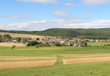
![Trail On foot Weimar (Lahn) - [W1] Rundweg durch die Gemeinde Weimar (Lahn) - Photo](https://media.geolcdn.com/t/1900/400/3bc795d5-8ccb-48ab-b7f6-fe7f27730326.jpeg&format=pjpeg&maxdim=2)

Tous les sentiers balisés d’Europe GUIDE+


FREE GPS app for hiking
 SityTrail
IGN / Geographical institutes
SityTrail World
The world is yours!
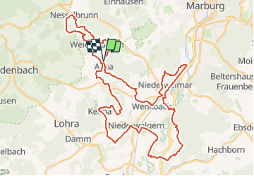
Trail On foot of 50 km to be discovered at Hesse, Landkreis Marburg-Biedenkopf, Weimar (Lahn). This trail is proposed by SityTrail - itinéraires balisés pédestres.
Trail created by Gemeinde Weimar (Lahn).
Symbol: Gelber Text "W1" auf schwarzem Hintergrund
![Trail On foot Weimar (Lahn) - [W1] Rundweg durch die Gemeinde Weimar (Lahn) - Photo 1](https://media.geolcdn.com/t/2048/auto/5315a4e8-56d7-4a23-9b53-67ad8b3b0bac.jpeg&format=jpg&maxdim=0 "Trail On foot Weimar (Lahn) - [W1] Rundweg durch die Gemeinde Weimar (Lahn) - Photo 1")
![Trail On foot Weimar (Lahn) - [W1] Rundweg durch die Gemeinde Weimar (Lahn) - Photo 2](https://media.geolcdn.com/t/2048/auto/2fcf05ab-bf8a-461d-a25b-c1b8172c29a1.jpeg&format=jpg&maxdim=0 "Trail On foot Weimar (Lahn) - [W1] Rundweg durch die Gemeinde Weimar (Lahn) - Photo 2")
![Trail On foot Weimar (Lahn) - [W1] Rundweg durch die Gemeinde Weimar (Lahn) - Photo 3](https://media.geolcdn.com/t/2048/auto/3bc795d5-8ccb-48ab-b7f6-fe7f27730326.jpeg&format=jpg&maxdim=0 "Trail On foot Weimar (Lahn) - [W1] Rundweg durch die Gemeinde Weimar (Lahn) - Photo 3")
![Trail On foot Weimar (Lahn) - [W1] Rundweg durch die Gemeinde Weimar (Lahn) - Photo 4](https://media.geolcdn.com/t/2048/auto/df846e12-5a8a-4fed-8fd8-1f31fd1780c0.jpeg&format=jpg&maxdim=0 "Trail On foot Weimar (Lahn) - [W1] Rundweg durch die Gemeinde Weimar (Lahn) - Photo 4")
![Trail On foot Weimar (Lahn) - [W1] Rundweg durch die Gemeinde Weimar (Lahn) - Photo 5](https://media.geolcdn.com/t/2048/auto/29db04a5-46b7-4e72-9137-fe47e864b39f.jpeg&format=jpg&maxdim=0 "Trail On foot Weimar (Lahn) - [W1] Rundweg durch die Gemeinde Weimar (Lahn) - Photo 5")
![Trail On foot Weimar (Lahn) - [W1] Rundweg durch die Gemeinde Weimar (Lahn) - Photo 6](https://media.geolcdn.com/t/2048/auto/67dc412d-83e9-4b59-a6de-a2ca5aa00141.jpeg&format=jpg&maxdim=0 "Trail On foot Weimar (Lahn) - [W1] Rundweg durch die Gemeinde Weimar (Lahn) - Photo 6")
![Trail On foot Weimar (Lahn) - [W1] Rundweg durch die Gemeinde Weimar (Lahn) - Photo 7](https://media.geolcdn.com/t/2048/auto/40ff3de6-fc07-4fd3-8676-5e47668b1ac1.jpeg&format=jpg&maxdim=0 "Trail On foot Weimar (Lahn) - [W1] Rundweg durch die Gemeinde Weimar (Lahn) - Photo 7")
![Trail On foot Weimar (Lahn) - [W1] Rundweg durch die Gemeinde Weimar (Lahn) - Photo 8](https://media.geolcdn.com/t/2048/auto/f5153156-6f06-4603-b3b8-7256b8f991b7.jpeg&format=jpg&maxdim=0 "Trail On foot Weimar (Lahn) - [W1] Rundweg durch die Gemeinde Weimar (Lahn) - Photo 8")
![Trail On foot Weimar (Lahn) - [W1] Rundweg durch die Gemeinde Weimar (Lahn) - Photo 9](https://media.geolcdn.com/t/2048/auto/b9bc3716-b6c8-4bc5-9b11-08b39f4ac316.jpeg&format=jpg&maxdim=0 "Trail On foot Weimar (Lahn) - [W1] Rundweg durch die Gemeinde Weimar (Lahn) - Photo 9")
![Trail On foot Weimar (Lahn) - [W1] Rundweg durch die Gemeinde Weimar (Lahn) - Photo 10](https://media.geolcdn.com/t/2048/auto/50536660-80b4-4636-aebc-da028ff714d4.jpeg&format=jpg&maxdim=0 "Trail On foot Weimar (Lahn) - [W1] Rundweg durch die Gemeinde Weimar (Lahn) - Photo 10")
On foot
On foot
On foot
On foot
![Trail On foot Marburg - [C2] Rundwanderweg Elisabethkirche Dammühle - Photo](https://media.geolcdn.com/t/375/260/d862ce6a-ca96-4f59-9c5d-a597e44ddacb.jpeg&format=jpg&maxdim=2)
On foot
![Trail On foot Marburg - [D3] Rundwanderweg Stadtwald Niederweimar - Photo](https://media.geolcdn.com/t/375/260/5315a4e8-56d7-4a23-9b53-67ad8b3b0bac.jpeg&format=jpg&maxdim=2)
On foot
![Trail On foot Marburg - [D6] Rundwanderweg Rumpeltal - Photo](https://media.geolcdn.com/t/375/260/f5b1abdc-c4ab-41bf-89af-120541dea1b9.jpeg&format=jpg&maxdim=2)
On foot
On foot
![Trail On foot Weimar (Lahn) - [W7] Ortsrundweg Niederwalgern - Kehna - Stedebach - Niederwalgern - Photo](https://media.geolcdn.com/t/375/260/2a98fd64-b158-468b-bf37-6a7c1e3c189d.jpeg&format=jpg&maxdim=2)
On foot